Geospatial data science: Improving public services

Geospatial technologies offer a practical and cost-effective way to improve public services, writes Vivienne Kelly, Managing Director of Compass Informatics.
Public sector bodies are eager to share data and are open to new initiatives to deliver better outcomes. They face many challenges, however, including inability to access data and concerns about the quality of the data.
Public sector bodies have a well-established culture of data sharing and data quality management. More importantly, they are open to new initiatives to harmonise the re-use of data to create efficiencies. That is according to a 2023 survey by the Office of the Government Chief Information Officer (OGCIO). In my experience with Compass Informatics, working with more than 50 public sector organisations, this is true. There is a genuine appetite among those working in state bodies to take a pragmatic and cost-effective approach to data sharing.
Innovative public sector bodies face challenges, however, in their quest to get the best from the wealth of data that exists. The OGCIO survey found that the potential for data re-use is hampered by the difficulty of accessing the data. In addition, the quality of the data is inconsistent, and duplication can inhibit efficiencies.
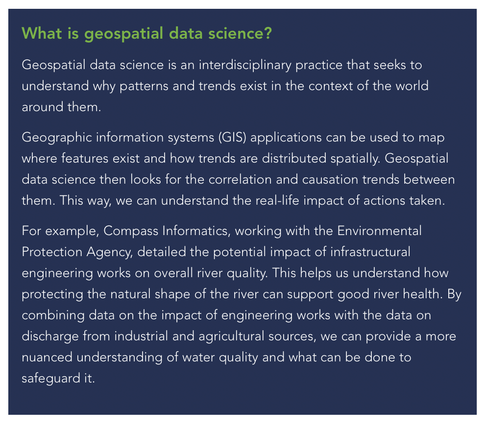
Geospatial data science, Geographic Information Systems (GIS) and emerging Earth Observation technologies offer public service bodies an accessible way to overcome these obstacles. Using these innovations, we can take disparate datasets representing real world features and combine them with geographical, environmental, socio-economic and infrastructural perspectives. Furthermore, geospatial data science and earth observation can be augmented by machine learning processes in powerful, cloud computing environments to carry out analysis on big geospatial datasets in a more rapid manner than ever before.
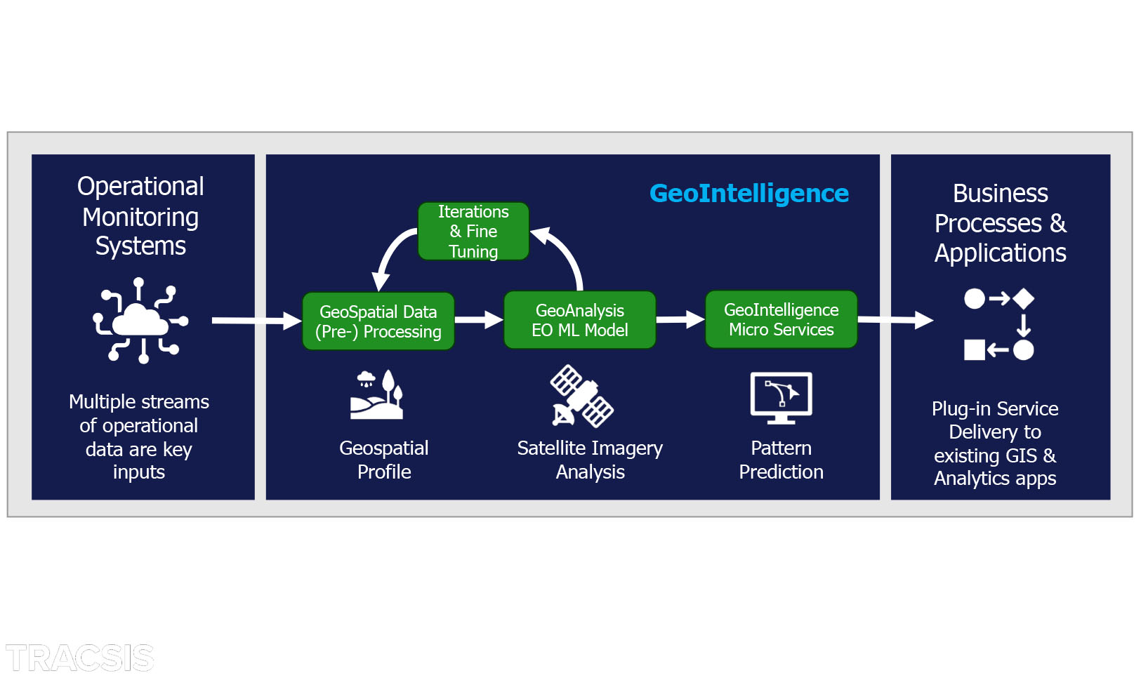
The GeoIntelligence Service provided by Compass Informatics offers a complete process to incorporate disparate datasets from multiple sources, create a geospatial profile and apply machine learning and AI algorithms to earth observation data, delivering deeper insights and near real time change detection directly to an organisation’s existing GIS and business intelligence applications.
Much can be achieved by combining existing data in meaningful ways, without the need to gather large amounts of new data. Because Compass Informatics works across multiple public sector bodies, we are able to identify and access disparate data streams. We are doing just this with Healthy Ireland Local Government, a new initiative in partnership with the Department of Health. We are re-using existing data from across the public sector to build understanding of community wellbeing. The only new data that will be created for this programme will be specific measurements of the impact of community wellbeing actions.
The National Transport Authority (NTA) has also availed of our technical expertise to gain fresh insights by combining existing datasets. We are combining transport infrastructure data with socio-economic data to allow the NTA to understand how communities access services such as GPs and dentists as well as opportunities for education and employment. This wider lens supports the NTA in planning for more equitable access to public transport.
The problem of inconsistent data quality seems like a wicked one but with our expertise, public bodies have successfully addressed it. We have supported the Marine Institute to develop a data management quality management framework that defines data process quality and provenance. This data management quality management framework is internationally recognised as a benchmark that can be applied across multiple sectors. Creating datasets with strong data quality principles is just one side of the coin. Through a deeper understanding of data provenance, even poorer quality data can be harnessed, as long as the quality is factored in. Addressing data quality is ever more important with the advance of AI.
Thanks to these new data technologies, policymakers, regulators, and planners have access to a deeper understanding than ever before of how real-world features are influenced by their locale. But they can also quantify how changes they make to that locale impact the world around them. The beauty of this new capability is how quickly organisations can see results. We can assess the impact of public service initiatives in a rapid cycle of plan-do-check-act. Compass Informatics applies machine learning processes to geospatial and earth observation fields, and this enables us to identify changes more rapidly and across a larger area than previously possible.
We are implementing this approach as lead partners in the Area Monitoring System, an EU initiative of the Common Agricultural Programme and the Department of Agriculture, Food and the Marine (DAFM). In this programme, we combine earth observation processes and satellite imagery to monitor agriculture at a national level. This framework could readily be applied to monitor change across land use, infrastructure, environment and much more.
Our experience as partners with multiple public sector organisations has been extremely positive and productive. People in the public sector are, indeed, hungry to innovate by sharing and re-using good quality data, and by augmenting that data. They understand the power of the insights gleaned from this process, how they can use them to inform strategy and operations that will benefit the citizen. Compass Informatics is providing the technical expertise to empower public bodies to realise these ambitions in a cost-effective way.
Compass Informatics
Vivienne Kelly is managing director of Compass Informatics, a geospatial consultancy service, providing expertise in geographic information systems (GIS), data science, custom application development and geospatial data strategies.
T: 01 210 4580
E: vkelly@compass.ie / info@compass.ie
W: www.compassinformatics.com