Navigating Dublin
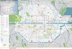
 Aris Venetikidis tells eolas about his map of a better transport system for Dublin.
To a German-born student in 2002, Dublin’s public transport system was “wanting” when it came to finding the right route. Recalling his frustrations, Aris Venetikidis explains how, as a designer, he set out to make order out of chaos.
“I had been used to transport maps in Germany and no map in Dublin even came close to such standards. I was utterly lost,” he remarks.
Working with environmental campaigner James Nix, he mapped out an idealised public transport system, designed to make sense to most people, “even visitors and people without knowledge of Dublin”. It draws on designs elsewhere, such as Henry Beck’s famous London Underground map and examples from his home region, the Ruhr Valley.
Public transport, in Venetikidis’ view, plays a key role in a city’s economy but Dublin has fallen far behind. “Innovative concepts and a bit of courage” are needed to take its system forward.
“Every map has a particular purpose” and while the best public transport ones contain plenty of information, they can end up as large and complex maps.
“The best way to keep a public transport map at useful sizes is geographic spatial distortion. In my own public transport maps I enlarged key areas, like the city centre or key streets, disproportionately,” he explains. O’Connell Bridge is therefore as wide as the entire Temple Bar district.
“Public transport routes have to be simplified into straightened lines with few bends. The city then has to be wrapped around these.”
In a cultural twist, the bus routes are granted Irish literary and historical names e.g. Larkin, Ulysses, Yeats and Gulliver.
Interest in the map was low at first but the Irish Environmental Network helped him to raise its profile. Doors started to open after a full page Irish Times article by Frank McDonald. Blog discussions and coverage in other major newspapers has followed, culminating in the Irish Design Institute’s 2010 Graduate Design Grand Prix Award.
“Sadly, a major shift in Dublin’s transport planning would be necessary,” Venetikidis reflects. “A clear hierarchy of transport modes from rapid to local modes, true integration, major simplification, centralised transport and route planning are needed, as well as a departure from unaffordable prestige projects. I hope my maps can serve as a reference point.”
The map is featured in the Institute of Designers in Ireland exhibition at the Glasnevin Museum from 2 December. For more information see: www.aris.ie


